Area
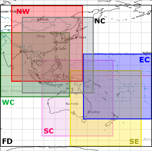
Data sets of six areas are provided in this service. Please select Area Name from menu bar when you download data.
Definition of areas and information is indicated by right figure and table below.
| Abbr. |
Area Name |
Latitude |
Longitude |
Sum of Size |
| NC |
North Central |
55N-15S |
90E-155E |
2.3 GB/3day |
| NW |
Northwest |
65N-5S |
80E-145E |
2.1 GB/3day |
| SC |
South Central |
15N-55S |
107.5E-172.5E |
2.2 GB/3day |
| SE |
Southeast |
6N-65S |
135E-200E |
2.1 GB/3day |
| EC |
East Central |
20N-40S |
145E-210E |
1.9 GB/3day |
| WC |
West Central |
40N-20S |
70E-135E |
2.0 GB/3day |
| FD |
Full Domain |
65N-65S |
70E-210E |
9.7 GB/3day |
|
 |
.
Specification
Data of each area includes 1) Satellite Imagery of Himawari-8/9, 2) NWP Products and 3) Observation Data. Specification of these data is shown in table below.
| Satellite Imagery of Himawari-8/9 |
| List of the channel |
Infrared channel-1 (Band 13) |
| Infrared channel-2 (Band 15) |
| Water Vapor (Band 8) |
| Infrared channel-4 (Band 7) |
| Visible imagery (Band 3) |
| Interval |
ten minutes each |
| Size |
2-4 MB/file |
|
|
| NWP Products |
| Resolution |
1.25 x 1.25 deg |
| Forecast hour |
up to 48 hours |
| Initial time |
00, 06, 12, 18 UTC |
| Interval |
4 times/day (around 04, 10, 16, 22 UTC) |
| Size |
4 MB/file |
| 15 MB/file (Full Domain) |
| SST (Sea surface temperature) |
| Interval |
Once/day |
| Size |
700 KB/file |
|
| Observation |
| SYNOP |
| Interval |
hourly |
| Size |
120-160 KB/file (map time) |
| 40-70 KB/file (other) |
|
| SHIP |
| Interval |
hourly |
| Size |
20-50 KB/file |
|
| METAR |
| Interval |
hourly |
| Size |
200-270 KB/file |
|
| TEMP (A, B) |
| Interval |
12 hour/day, basically |
| Size |
120 KB/file |
|
| ASCAT sea-surface wind |
| Interval |
hourly |
| Size |
7 MB/file |
|
- Data are stored for 3 days.
- Data format is all for SATAID.
 Data for SATAID